The Dharchula to Adi Kailash distance by road is approximately 130 kilometres — and yet, no number has ever truly captured what those kilometres feel like. The road climbs from a warm river-border town into a world of glacial silence, ancient forest, roaring tributaries, and finally, the towering white outline of Adi Kailash itself rising against an impossibly blue sky.
For pilgrims, this is one of India's most sacred journeys. For trekkers, it is one of the Kumaon Himalaya's most rewarding routes. For anyone who makes it to Jolingkong and stands at the base of Chhota Kailash, it is simply unforgettable. This guide breaks down every stretch of that 130 km, tells you what to expect at each stop, and gives you the practical knowledge to plan your trip with confidence.
Understanding the Dharchula to Adi Kailash Distance
When people ask about the Dharchula to Adi Kailash distance, the answer depends on how you are travelling. By road, the total distance is around 130 kilometres — broken into two main legs. The first leg runs from Dharchula to Gunji, covering roughly 90 kilometres of mountain road through remote Bhotia villages, dense oak and rhododendron forests, and dramatic river gorges carved by the Kali and its many tributaries. The second leg, from Gunji to Jolingkong (the base of Adi Kailash), adds another 40 kilometres of increasingly rugged terrain.
From Jolingkong, vehicles are not permitted to go further out of respect for the sanctity of the area. Pilgrims walk the final 3 to 4 kilometres on foot to reach Parvati Sarovar and the Adi Kailash Temple — a short but deeply moving section that most describe as the spiritual climax of the entire journey.
It is worth noting that until 2021, reaching Adi Kailash required a gruelling 200-kilometre trek from Dharchula that would take many days on foot. The newly constructed road to Jolingkong changed everything. Today, the same pilgrimage is accessible to a far wider range of devotees, though the high altitude and mountain terrain still demand serious preparation.
The Full Route from Dharchula to Adi Kailash — Stop by Stop
The journey does not begin the moment you leave Dharchula — it begins the night before, when you pack your bag, check your permits, and feel that quiet mix of excitement and reverence that every pilgrim knows. Here is a detailed look at each stage of the route, so you arrive at each stop knowing exactly what awaits you.
1.Dharchula — The Starting Point (940 m)
0 km · Starting base
Dharchula is a compact border town perched on the banks of the Kali River, which serves as the natural boundary between India and Nepal. Despite its small size, it is a place full of character. The markets are lively, the guesthouses are friendly, and the mix of Indian and Nepali cultures gives the town a unique warmth that many travellers find surprisingly inviting.
This is where all administrative formalities take place. Your Inner Line Permit (ILP) must be obtained from the SDM office here, and a medical fitness check is also conducted before you are cleared to proceed into the high-altitude zone. Most tour operators recommend spending at least one full day in Dharchula for rest and paperwork before setting off early the next morning. It is also the last place where ATMs are functional, so carry enough cash for the entire yatra.Tawaghat → Pangu → Budhi
35 km from Dharchula · 2–2.5 hrs
Leaving Dharchula, the road almost immediately begins to narrow and ascend. Tawaghat, just a few kilometres out, is where the formal mountain road begins in earnest. The Kali River roars below on your left as the vehicle climbs through dense mixed forest. The air is noticeably cooler than the town, and the first real Himalayan views begin to open up on the right-hand side.
2.Tawaghat → Pangu → Budhi
35 km from Dharchula · 2–2.5 hrs
Leaving Dharchula, the road almost immediately begins to narrow and ascend. Tawaghat, just a few kilometres out, is where the formal mountain road begins in earnest. The Kali River roars below on your left as the vehicle climbs through dense mixed forest. The air is noticeably cooler than the town, and the first real Himalayan views begin to open up on the right-hand side.
Pangu and Budhi are small Bhotia villages that appear like quiet islands in the middle of the wilderness. Life here is simple and deeply rooted in tradition. Stone houses, terraced fields, and prayer flags strung between pine trees characterise these settlements. The road quality in this stretch is uneven — expect some rocky patches and occasional narrow sections where vehicles must slow significantly. This is all part of the experience.
3.Gala → Chiyalekh Meadows → Garbyang
55–70 km from Dharchula · 3.5–4 hrs
This middle section of the route is where the landscape transforms dramatically. Gala is a small village where the valley begins to widen, and the scale of the surrounding peaks starts to register properly. The forest gives way to high-altitude shrubland, and on clear days, the distant snowline becomes visible above the ridgelines.
Chiyalekh Meadows is one of the most beautiful natural spots on the entire route. Sitting at altitude with views of Mount Api, Nanjing Parvat, and the Annapurna Range across the Nepalese border, this grassy expanse offers a moment of pure Himalayan grandeur. Many travellers stop here just to breathe it in. Garbyang, a little further along, is one of the historically significant villages of the Kumaon hills — once a thriving centre of trans-Himalayan trade with Tibet, its old stone architecture and traditional culture still survive remarkably well.
4.Gunji — The Base Village (3,200 m)
90 km from Dharchula · 5–6 hrs total
Gunji is the nerve centre of the Adi Kailash and Om Parvat Yatra. This quiet village, sitting at 3,200 metres above sea level near the India-Tibet border, serves as the base camp and acclimatisation point for almost all pilgrims and trekkers. It is also the junction where the routes to Adi Kailash (via Nabi and Jolingkong) and Om Parvat (via Kalapani and Nabidhang) diverge.
Most itineraries build in a half-day or full rest day at Gunji, and for good reason. The altitude jump from Dharchula is significant, and altitude mountain sickness (AMS) becomes a real concern beyond this point. Spend time hydrating, eating light, and letting your body adjust. Guest houses and homestays in Gunji offer basic but comfortable accommodation, and the views of Ganesh Parvat from the village in the early morning are something many visitors describe as a spiritual experience in themselves.
5.Nabi → Kuti → Jolingkong (4,762 m)
40 km from Gunji · 2–3 hrs drive
The drive from Gunji to Jolingkong is the most dramatic stretch of the entire journey. The landscape becomes increasingly stark and alpine — trees disappear almost entirely, replaced by wind-scoured rock, glacial streams, and the occasional burst of wildflowers clinging to impossible slopes. The scale of everything grows larger with every kilometre.
Along the way, you will pass Nabi village, one of the highest permanently inhabited settlements in this part of Uttarakhand, and then Kuti, a small cluster of stone houses from where the old trade route to Tibet once ran. Keep your eyes open for Kunti Parvat, Pandav Fort, Brahma Parvat, and Parvati Mukut — a series of dramatic rocky peaks that loom over the valley like sentinels. The spiritual atmosphere in this section of the route is palpable; many pilgrims fall into a natural silence as the sacred landscape takes hold.
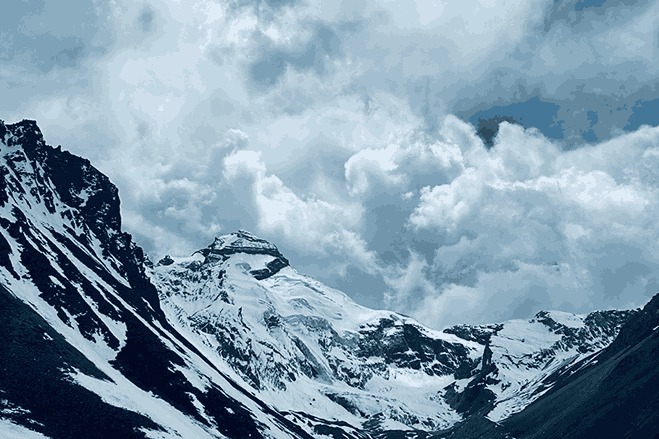
Jolingkong itself sits in a wide glacial bowl at 4,762 metres, surrounded by peaks on all sides. It is the end of the motorable road and the beginning of the sacred zone. Vehicles are stopped here, and the rest of the journey is made on foot.
6.Adi Kailash Temple & Parvati Sarovar

Dharchula: More Than Just a Gateway
It would be a mistake to treat Dharchula as a mere overnight stop before the real journey begins. This small town on the Indo-Nepal border has its own quiet depth. The Kali River, which separates Dharchula from Darchula (Nepal) across the water, creates an unusual atmosphere — you can stand on the Indian bank and watch life unfold on the Nepalese side just metres away. Many pilgrims use their rest day here to walk across and explore the Nepalese town, which is permitted for Indian citizens without a visa for short visits.
The local Bhotia and Rang communities have inhabited this region for centuries. Their culture is a fascinating blend of Tibetan, Nepali, and Kumaoni influences, shaped by generations of high-altitude trade along the ancient routes that led over the passes into Tibet. The traditional craft of weaving dan — handmade woollen carpets once bartered with Tibetan merchants for salt and grain — is still practised here, and the local markets are a good place to find authentic regional crafts.
From a practical standpoint, Dharchula is where everything happens before the yatra. The SDM office issues Inner Line Permits, the medical team conducts fitness checks, 4×4 vehicles are arranged, and essential supplies are purchased. The town has functioning ATMs, small pharmacies, and grocery stores — none of which you will find reliably beyond this point. Give yourself enough time here to handle all of this without rushing.
Permits and Documentation
Because the Adi Kailash route runs through a sensitive zone adjacent to both the India-Nepal and India-China borders, all travellers are required to hold an Inner Line Permit before proceeding beyond Dharchula. This is not a difficult process, but it does require advance preparation. The permit is issued by the Sub-Divisional Magistrate (SDM) office in Dharchula, and it can also be obtained in Pithoragarh if you are arriving from that direction.
| Permit name | Inner Line Permit (ILP) |
| Issued by | SDM Office, Dharchula or Pithoragarh |
| Documents required | Aadhaar Card or valid passport, passport-size photographs |
| Medical certificate | Required, especially for senior pilgrims (age 60+) |
| Valid beyond | All checkposts from Dharchula onwards |
| Om Parvat add-on | Separate Nabidhang darshan permit needed for Om Parvat |
What You Will Encounter Along the Route
Kalapani and the Kali Mandir
Vyas Gufa — The Cave of the Sage
Om Parvat — A Natural Wonder at Nabidhang
Sumchuma — The Miracle Stream
Practical Tips Before You Leave Dharchula
The Dharchula to Adi Kailash journey is not a casual weekend trip. It requires physical preparation, the right equipment, and a clear understanding of what the high-altitude environment demands. The good news is that with proper planning, the route is manageable for reasonably fit adults of all ages.
Start building your fitness at least a month before departure. Daily cardio — walking, running, or cycling — builds the aerobic base you will need at altitude. At Gunji, take your acclimatisation day seriously. Do not try to push through to Jolingkong too quickly; acute mountain sickness (AMS) can affect anyone, regardless of age or fitness level, and descending from 4,000+ metres is never pleasant. Drink at least 3–4 litres of water daily once you are above 3,000 metres.
Pack warm layers that can be added or removed easily, as temperatures fluctuate dramatically between midday sun and early morning cold at altitude. A waterproof outer layer is essential. Mobile networks stop working beyond Dharchula, so download offline maps and inform your family of your itinerary before departing. Carry a personal medical kit including altitude sickness tablets (consult a doctor before the trip), an oxygen can for emergencies, and any prescription medications you require. And carry ample cash — there are no ATMs, no card payment facilities, and no exceptions once you leave Dharchula.