You have done the popular treks. You have walked through Kedarkantha, maybe even Hampta Pass. But something still pulls you deeper. Something more raw, more spiritual, more demanding. If that feeling resonates, the Kinner Kailash trek was made for you.
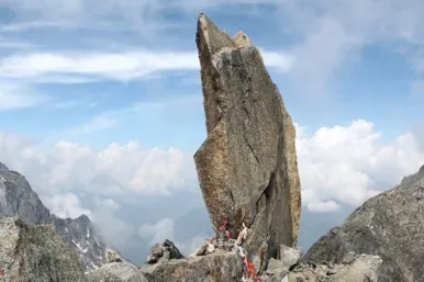
This is not just another mountain trail. This is a pilgrimage route that has tested the devotion of Hindu and Buddhist worshippers for centuries. The giant Shiva Lingam standing at the summit, changing colors with the movement of the sun, is something that no photograph can fully capture. It has to be witnessed in person.
But this trek comes with real challenges. The terrain is unforgiving. The altitude is brutal. The weather can shift in minutes. And without proper planning, the journey can become dangerous very quickly.
This guide gives you everything you need to know about the Kinner Kailash trek, from the route map and distance to permits, packing lists, and safety tips. Whether you are a spiritual seeker, an adventure enthusiast, or a seasoned trekker looking for your next big challenge, this guide will prepare you completely.
What Is the Kinner Kailash Trek
The Kinner Kailash trek is a high-altitude Himalayan trek located in the Kinnaur district of Himachal Pradesh. It is considered one of the Panch Kailash pilgrimage routes in Hindu mythology, the other four being Mani Mahesh Kailash, Srikhand Mahadev, Adi Kailash, and Mount Kailash in Tibet.
The centerpiece of this trek is a 79-foot natural rock formation that resembles a Shiva Lingam. This sacred structure sits at an altitude of approximately 4,800 meters above sea level. Pilgrims and trekkers from across India and the world come here each year to seek the blessings of Lord Shiva.
The trek is part of the larger Kinnaur Kailash range, a sub-range of the Himalayas that borders Tibet. The region is famous for its apple orchards, ancient Buddhist monasteries, dramatic rocky landscapes, and rich tribal culture.
Kinner Kailash Trek Route Map: Your Two Main Options
There are two well-established routes, and choosing the right one for your ability level matters a great deal.
Route 1: Thangi Route (The Classic Pilgrim Path)
This is the route most trekkers take. It is shorter, better marked, and has more support infrastructure along the way. The village of Thangi in the Baspa Valley serves as your launch point. The trail climbs steadily through pine forests, opens into high-altitude meadows, and then pushes through rocky terrain toward the summit.
| Day | Route | Distance | Walking Time |
|---|---|---|---|
| 1 | Reckong Peo → Kalpa | Drive only | Rest day |
| 2 | Kalpa → Thangi + short walk | 3–4 km | ~2 hrs |
| 3 | Thangi → Base Camp | 9–11 km | 6–8 hrs |
| 4 | Base Camp → Shiva Lingam → Back | 8–10 km | 6–8 hrs |
| 5 | Base Camp → Thangi | 9–11 km | 5–6 hrs |
Route 2: Chitkul Route (The Trekker's Choice)
This route starts from Chitkul, the last village on the Indian side of the Indo-Tibetan border. It is longer, more scenic, less crowded, and considerably harder. Experienced trekkers who want solitude and raw Himalayan wilderness prefer this path. It crosses higher ridges and demands more technical navigation.
| Day | Route | Distance | Walking Time |
|---|---|---|---|
| 1 | Chitkul → Lamkhaga Base | 10–12 km | 7–8 hrs |
| 2 | Lamkhaga Base → High Camp | 8–10 km | 6–7 hrs |
| 3 | High Camp → Shiva Lingam | 6–8 km | 5–6 hrs |
| 4 | Shiva Lingam → Thangi | 10–12 km | 6–7 hrs |
| 5 | Thangi → Reckong Peo | Drive only | — |
Kinner Kailash Trek Distance
One of the most common questions from aspiring trekkers is about the Kinner Kailash trek distance. Here is a clear breakdown.
From Thangi to the Shiva Lingam, the one-way distance is approximately 14 to 16 kilometers. The total Kinner Kailash trek distance for a complete round trip from Thangi is around 28 to 32 kilometers.If you take the Chitkul route, the Kinnaur Kailash trek km count is higher, ranging between 45 to 55 kilometers for the full circuit, depending on the exact path taken and detours made along the way.
Here is a stage-wise distance breakdown for the Thangi route:
- Thangi to Forest Camp: approximately 5 to 6 km
- Forest Camp to Base Camp: approximately 4 to 5 km
- Base Camp to Shiva Lingam: approximately 4 to 5 km
- Total one way: approximately 14 to 16 km
The altitude gain during this trek is significant. You start at Thangi, which sits at around 3,300 meters, and climb to the Shiva Lingam at approximately 4,800 meters. This means an elevation gain of over 1,500 meters in a relatively short horizontal distance, which makes the trail steep and physically demanding.

Best Time for the Kinner Kailash Trek
| Month | Conditions | Recommended |
|---|---|---|
| Jan – Apr | Heavy snow, trails blocked | No |
| May – Jun | Snow melting, unstable | Not ideal |
| July | Monsoon, slippery, landslides | Caution |
| August (Early) | Monsoon continues | Caution |
| Aug (Mid) – Sep | Clear, best conditions | Yes |
| October | Early snowfall | Borderline |
| Nov – Dec | Snow, inaccessible | No |
Difficulty Level and Fitness Requirements
The Kinner Kailash trek is rated as difficult to very difficult. It is not suitable for first-time trekkers or those without prior experience on high-altitude trails.
The challenges include:
- Steep and rocky terrain. Large portions of the trail involve climbing over loose rocks and boulders. There are no paved paths. The footing can be unreliable, especially after rain.
- Altitude and thin air. Most of the trek is above 3,500 meters. Above 4,000 meters, oxygen levels drop significantly. Altitude sickness is a real risk and needs to be taken seriously.
- Unpredictable weather. Even in the best months, weather at high altitude can change within hours. Temperatures at Base Camp can drop below freezing at night, even in August.
- Physical demands. You will be walking 6 to 8 hours a day with a loaded backpack over steep trails. Strong legs, cardiovascular endurance, and core strength are essential.
Permits Required for the Kinner Kailash Trek
This is one aspect that trekkers often overlook, and it can derail your entire trip if not handled in advance.
- Because the Kinnaur district borders Tibet, it is a restricted area. All Indian nationals and foreign nationals require an Inner Line Permit (ILP) to enter certain zones within Kinnaur.
- Indian Nationals: You can obtain the ILP at the District Magistrate's office in Reckong Peo. It is generally issued on the same day. Carry multiple passport-sized photographs and a copy of your government-issued photo ID.
- Foreign Nationals: The process is more complex. Foreign nationals need to apply through the Ministry of Home Affairs and usually require the permit well in advance. Certain zones may be completely off-limits for foreign nationals.
- In addition to the ILP, you will need to register your trek at the Forest Department checkpost in Thangi before beginning the trail.
- Carry multiple copies of your permits at all times. Local checkposts along the route will verify them at multiple points.
How to Reach the Kinner Kailash Trek Starting Point
The most common starting points are Reckong Peo and Thangi. Here is how to reach them.
By Air: The nearest airport is Shimla (Jubbarhatti Airport). From Shimla, take a bus or hire a taxi to Reckong Peo, which takes approximately 7 to 8 hours.
By Train: The nearest railhead is Shimla on the Kalka-Shimla narrow gauge line. From Kalka, connect to the Shatabdi Express from Delhi and then take the toy train to Shimla.
By Road: From Delhi, take the NH5 to Shimla and then continue to Reckong Peo via Narkanda and Rampur. The total road distance from Delhi to Reckong Peo is approximately 580 to 620 kilometers. You can take a HRTC (Himachal Road Transport Corporation) bus from Delhi's ISBT Kashmere Gate to Reckong Peo. The journey takes around 16 to 18 hours.
From Reckong Peo, hire a shared or private taxi to Thangi. The drive takes about 3 to 4 hours on a winding mountain road.
What to Pack for the Kinner Kailash Trek
Packing smart can mean the difference between a comfortable experience and a miserable one.
Clothing:
- Thermal inner layers (top and bottom)
- Fleece jacket or mid-layer
- Waterproof and windproof outer jacket
- Trekking pants (quick-dry material)
- Warm hat, gloves, and neck gaiter
- Trekking socks (wool-based, at least 3 to 4 pairs)
- Sturdy ankle-support trekking boots (broken in before the trek)
- Camp sandals for evenings
Gear:
- Trekking poles (essential for steep descents)
- 50 to 60 liter backpack with rain cover
- Sleeping bag rated to minus 10 degrees Celsius
- Headlamp with extra batteries
- Sunglasses with UV protection (UV is intense at high altitude)
- Trekking gloves
Health and Safety:
- Diamox (acetazolamide) for altitude sickness prevention (consult a doctor before use)
- Personal first aid kit including ORS packets, pain relievers, antiseptic, bandages, and blister care
- Sunscreen with SPF 50 or higher
- Lip balm
- Water purification tablets
Food and Water:
- High-energy snacks: nuts, dry fruits, energy bars, dark chocolate
- Minimum 2 to 3 liters of water capacity (use a hydration bladder or bottles)
Documents:
- Government-issued ID (original and multiple copies)
- Inner Line Permit (multiple copies)
- Emergency contact list
- Travel insurance documents
Accommodation and Food on the Trek
Between Thangi and the Base Camp, there are very limited options for organized accommodation. Most trekkers camp along the route.In Thangi itself, there are basic guesthouses and dharamshalas. Food is simple but nourishing: dal, rice, roti, and sabzi. Do not expect variety. The focus here is sustenance, not cuisine.
At campsites along the route, you will either use your own tent or hire one from local outfitters in Thangi or Reckong Peo. Trekking agencies that offer guided Kinner Kailash trek packages typically include tent accommodation, sleeping bags, and meals as part of the package. At the Shiva Lingam area, there are small temporary shelters used during the pilgrimage season, but they are basic and unreliable. Always carry your own tent and sleeping bag.
Safety Tips for the Kinner Kailash Trek
- Never ignore altitude sickness symptoms. Headache, nausea, dizziness, and loss of appetite are early warning signs. If symptoms worsen, descend immediately. Do not push through serious altitude sickness. It can become life-threatening.
- Always trek with a guide if you are doing this for the first time. The trails are not always clearly marked, and weather conditions can create confusion.
- Start early each day. Most serious trekkers start by 4 to 5 AM on summit day to avoid afternoon cloud cover and ensure safe descent before dark.
- Carry a satellite communicator or at minimum ensure local guide has emergency contacts. Mobile network is unreliable or completely absent on most of the trail.
- Respect the environment. Do not litter. Carry back all non-biodegradable waste. The region is ecologically fragile and spiritually significant.