You've heard the name whispered in reverence among Shiva devotees. You've seen the photographs — a towering natural Shivalinga rising from snow-covered slopes at nearly 17,000 feet, surrounded by 72 glacial lakes, mythic rivers, and paths walked by sages for centuries. But you've also heard this: the Shrikhand Mahadev trekking distance is brutal.
And that's exactly why most people hesitate — and exactly why this guide exists.
In this guide, we cover every kilometer of the Shrikhand trek — from the first step at Jaon village to the moment you bow before the sacred Shivalinga at the summit. Let's begin.
Shrikhand Mahadev Trek Distance: The Complete KM Breakdown
Let's answer the most-searched question directly: the total Shrikhand Mahadev trek distance is approximately 35 kilometres one-way, starting from Jaon village in Himachal Pradesh's Kullu district. The round trip totals roughly 70 kilometres.
But distance alone tells an incomplete story. This is not a flat 70 km walk. You are climbing from 2,390 metres to 5,227 metres — a net altitude gain of over 2,800 metres — across rocky moraine, steep ice fields, boulders, and snow-laden ridgelines. Every kilometre here feels harder than three on flat terrain.
Shrikhand Mahadev Trek KM: Day-by-Day Distance
Here's how the 35 km unfolds across typical trekking days:
| Day | Route | Distance | Altitude | Difficulty |
|---|---|---|---|---|
| 1 | Jaon → Singhad | ~6 km | 2390 → 2920 m | Moderate |
| 2 | Singhad → Thachru | ~9 km | 2920 → 3450 m | Moderate–Hard |
| 3 | Thachru → Bheem Dwar → Parvati Bagh | ~11 km | 3450 → 4390 m | Very Hard |
| 4 | Parvati Bagh → Peak → Thachru | ~9 km | 4390 → 5227 m | Extreme |
| 5 | Thachru → Singhad → Jaon | ~15 km | 3450 → 2390 m | Moderate |
⚠️ Important Note on Distance
The 35 km figure refers to the standard route via Jaon → Singhad → Thachru → Parvati Bagh → Shrikhand Summit. Some sources cite slightly different figures (32 km to 38 km) because GPS measurements vary by route taken across glacial terrain. The elevation profile matters far more than the exact kilometre count when planning your fitness training.
Shrikhand Mahadev Trek Map: Key Stops Along the Route
The Shrikhand Mahadev trek map follows a single corridor through the Kullu district, starting at Jaon — a small village 60 km from Rampur town. There are no alternate routes; all pilgrims and trekkers share the same path. Here are the key landmarks you will encounter:
What Each Landmark Means
Jaon Village
Jaon Village is your starting point and the last place to stock up on supplies. Most trekkers overnight here before beginning at dawn.
Singhad
Singhad is the official registration and check-in point managed by the Himachal Pradesh government during the trekking season. You must register here. It also marks the end of the easy section — the gradient sharpens beyond this point.
Thachru
Thachru is the most important logistical stop. Tents, dhabas serving simple food, and medical assistance are available here during the season. If you develop AMS (Acute Mountain Sickness), Thachru is where you descend to.
Bheem Dwar
Bheem Dwar is both a mythological landmark (believed to be the gate through which the Pandavas passed) and a critical acclimatization point. The terrain becomes significantly rockier and steeper from here.
Parvati Bagh
Parvati Bagh is a surreal meadow at 4,390 metres, named after Goddess Parvati. Glacial lakes dot the landscape here. Most trekkers camp here for summit day.
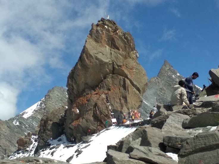
The Summit
The Summit — the sacred natural Shivalinga of Lord Shiva — sits at 5,227 metres (17,150 feet). Devotees offer water, milk, and prayers before beginning the descent.
Shrikhand Mahadev Height in Feet & Temperature: What to Expect
Understanding the altitude profile is crucial — not just for planning, but for safety.
Shrikhand Mahadev Height
At 17,150 feet, the summit has approximately 30% less oxygen than sea level. This is the primary reason the trek demands serious physical preparation. Altitude sickness, if ignored, can be fatal.

Shrikhand Mahadev Temperature by Section
| Month | Conditions | Status | Recommended |
|---|---|---|---|
| Jan – May | Heavy snow | Closed | No |
| June (Late) | Snow melting | Opening | Early season |
| July – Aug 15 | Clear trails | Best | ✓ Highly Recommended |
| Aug (Late) | Monsoon, landslides | Closing | Avoid |
| Sep – Dec | Fresh snowfall | Closed | No |
Temperature Warning
Temperatures at the summit drop rapidly in the afternoon — plan to reach the Shivalinga before noon. Sudden snowfall is common even in peak season (July–August). Wind chill at the summit can make it feel as cold as -20°C. Always carry a -10°C sleeping bag, thermal layers, waterproof jacket, and micro-spikes for ice.
Shrikhand Mahadev Trek Best Time: Month-by-Month Guide
The trekking window for Shrikhand is narrow. Unlike many Himalayan treks accessible across multiple seasons, the extreme altitude and glaciated terrain limit the safe trekking window to roughly 6–8 weeks per year.
| Month | Conditions | Status | Recommended |
|---|---|---|---|
| Jan – May | Heavy snow | Closed | No |
| June (Late) | Snow melting | Opening | Early |
| July – Aug 15 | Clear trails | Best | ✓ Yes |
| Aug (Late) | Monsoon, landslides | Closing | Avoid |
| Sep – Dec | Fresh snowfall | Closed | No |
The single best time is the fortnight around Sawan Shivratri (usually late July or early August). Hundreds of thousands of devotees undertake the trek during this period. The atmosphere is electric with devotion, chanting, and the sound of "Bam Bam Bhole."
For a less crowded experience, the last week of June and the first week of July offer good conditions with far fewer trekkers.
Shrikhand Trek Preparation: Essential Tips Before You Go
Physical Fitness Requirements
This is not a beginner trek. You should be comfortable hiking 15–20 km per day on hilly terrain with a backpack before attempting Shrikhand. Start training at least 8–10 weeks in advance with daily cardio, stair climbing, and loaded hikes.
Acclimatization Strategy
Do not rush. The most common mistake is moving too fast and developing Acute Mountain Sickness (AMS). Follow the golden rule: climb high, sleep low. On Day 3, consider spending extra time at Bheem Dwar before pushing to Parvati Bagh.
Essential Gear List
Packing Checklist
Waterproof trekking boots with ankle support (broken-in before the trek)
Trekking poles — mandatory for rocky descent sections
Thermal base layer (top and bottom), fleece mid-layer, waterproof shell jacket
Sleeping bag rated to -10°C or below
Micro-spikes for ice patches near the summit
High-altitude medicine kit: Diamox (consult doctor), Ibuprofen, ORS, Dextrose
Sunscreen SPF 50+, UV-protection sunglasses, gloves, wool hat
4–5 litres water-carrying capacity + water purification tablets
High-calorie snacks: nuts, dates, energy bars, dark chocolate
Headlamp with extra batteries (summit push starts at 2–3 AM)
Shrikhand Mahadev Trek Opening Date 2026
| Detail | Info |
|---|---|
| Opening Date | 15 July 2026 (tentative) |
| Closing Date | 15 Aug 2026 (tentative) |
| Open Window | 15–20 days |
| Auspicious Period | Sawan Shivratri, Guru Purnima |
| Official By | HP Govt + Yatra Trust |
⚠️ Important Notes for 2026
The Shrikhand Mahadev opening date 2026 is expected around 15 July 2026, subject to confirmation from the Himachal Pradesh government and local authorities. The yatra typically remains open until 15 August 2026. Divine Kailash
The 2026 tentative dates are likely to fall between the third week of July and the first week of August, subject to final confirmation by the authorities. JustWravel
One source also notes the trek opening date as 02 June 2026 — this likely refers to the trail becoming physically passable, not the official government-organized yatra window.