You've done your research. You've seen the photographs. And now you're asking the one question every serious trekker asks before lacing up their boots: exactly how far is the Kinner Kailash trek, and can I actually do it?
The Kinner Kailash trek distance of approximately 14 km one-way sounds manageable on paper. But those 14 kilometres climb nearly 2,000 metres through steep rocky trails, exposed ridges, and thin Himalayan air — all leading to one of the most sacred peaks in all of India. This is not just a trek. It is a pilgrimage.
In this complete 2026 guide, we cover every detail: the Kinner Kailash trek km breakdown, the full route map, the Kinner Kailash height in feet, the expected opening date for 2026, permits, gear, and everything else you need to reach the divine Shivling safely.
What is the Kinner Kailash Trek Distance?
The Kinner Kailash trek distance is approximately 14 kilometres one-way from Thangi village to the base of the sacred Shivling. The return journey makes the total trekking distance roughly 28 km over two days.
However, these numbers tell only part of the story. Every kilometre of this route climbs steeply — through boulder fields, narrow goat trails, and exposed mountain ridges at altitudes that challenge even experienced Himalayan trekkers. The total Kinner Kailash trek km should never be compared to a flat trail.
Most trekkers begin at Thangi village (2,900 m / 9,514 ft), around 30 km by road from Reckong Peo. Some routes start from Powari village, which adds a few additional kilometres to the overall distance.
Kinner Kailash Trek km — Section-by-Section Breakdown
| Section | Distance | Elevation Gain |
|---|---|---|
| Reckong Peo → Thangi | ~30 km | Base approach |
| Thangi → Lalanti | ~6 km | +600 m |
| Lalanti → Shivling Base | ~5 km | +900 m |
| Shivling Base → Viewpoint | ~3 km | +350 m |
| One Way Trek | ~14 km | ~1850 m |
| Round Trip | ~28 km | Full descent |
Quick Answer: The Kinner Kailash trek distance is 14 km one-way from Thangi village. The complete parikrama circuit (including Charang Pass crossing) covers approximately 80 km over 5–7 days and is only for highly experienced trekkers.
Kinner Kailash Height in Feet: What You Need to Know
Kinner Kailash height in feet is 19,882 feet (6,050 metres) above sea level. This places it among the highest sacred peaks in the entire Himalayan range, towering over the Baspa Valley in Kinnaur district of Himachal Pradesh.
It is important to distinguish between two elevations when planning your trek:
- The summit of Kinner Kailash: 6,050 m / 19,882 ft — attempted only by technical mountaineers
- The Shivling base camp (trekking goal for most visitors): ~4,700 m / 15,420 ft
For practical purposes, the Kinner Kailash height that affects most trekkers and pilgrims is the high camp at around 15,000 feet. At this altitude, the air carries roughly 40% less oxygen than at sea level — making acclimatisation non-negotiable.

Elevation Profile: Key Points on the Trek
| Location | Elevation (m) | Height (ft) |
|---|---|---|
| Reckong Peo | 2290 m | 7513 ft |
| Thangi Village | 2900 m | 9514 ft |
| Lalanti Campsite | 3500 m | 11483 ft |
| Shivling Base Camp | 4700 m | 15420 ft |
| Kinner Kailash Summit | 6050 m | 19882 ft |
⚠️Health Advisory: At the Shivling base alone (~15,000 ft), acute mountain sickness (AMS) is a genuine risk. Symptoms include headache, nausea, and breathlessness. Consult a doctor before attempting this trek if you have any cardiac, respiratory, or blood pressure conditions. Always carry Diamox and a pulse oximeter.
Kinner Kailash Trek Route Map — Day-by-Day Itinerary
A well-planned Kinner Kailash trek route map is your most important preparation tool. The terrain is rugged, waypoints are limited, and weather changes rapidly above 4,000 m. Below is the standard 4-day itinerary used by most trekking agencies and pilgrims.
Standard 4-Day Kinner Kailash Trek Itinerary
| Day | Route | Distance | Max Elevation |
|---|---|---|---|
| 1 | Shimla / Chandigarh → Reckong Peo | ~230 km | 2290 m |
| 2 | Reckong Peo → Thangi → Lalanti | 30 km + 6 km | 3500 m |
| 3 | Lalanti → Shivling Base → Return | ~16 km | 4700 m |
| 4 | Lalanti → Thangi → Reckong Peo | 6 km + road | 2290 m |
Extended Parikrama Circuit (5–7 days): Those undertaking the full sacred circumambulation via Charang Pass (5,241 m / 17,192 ft) should plan a minimum of 6 days with a skilled local guide. The Kinner Kailash parikrama circuit covers approximately 80 km and is suitable only for highly experienced trekkers.
Pro Tip: Download an offline GPS map of the Kinner Kailash trek route before you leave civilisation. Mobile networks become unreliable beyond Reckong Peo. Apps like Maps.me or Gaia GPS have reasonable offline coverage for the Kinnaur valley.
Kinner Kailash Opening Date 2026 — When Can You Trek?
The official Kinner Kailash opening date 2026 is announced by the District Magistrate of Kinnaur, Himachal Pradesh, typically in late May or early June each year. As of this writing, the formal Kinner Kailash trek opening date 2026 has not been declared — but historical patterns give us a reliable estimate.
Based on data from 2020–2024, here is what trekkers and pilgrims can expect:
| Detail | Info |
|---|---|
| Opening Date | Late Jun – Early Jul 2026 |
| Announced By | Kinnaur DM (HP Govt) |
| Best Window | 15 Jul – 15 Sep 2026 |
| Closure | Mid-Oct 2026 |
| Permit Registration | With season start |
Kinner Kailash 2026 Season at a Glance
Important: The Kinner Kailash opening date 2026 is weather-dependent. Heavy snowfall can delay the opening until mid-July. We strongly recommend confirming the official date with the District Administration Kinnaur or the HP Tourism Department before booking travel.
Month-by-Month Trekking Season Guide
Best months to visit:
July: Trail freshly opens; lush green hillsides, some rainfall — magical but muddy
August: Peak pilgrimage season; trails are busiest; wildflowers bloom across meadows
September: Ideal conditions — post-monsoon clarity, stable weather, stunning views
Early October: Crisp mountain air and golden landscapes; early snowfall possible above 4,000 m
Months to avoid:
November to May: Trail completely buried under snow; impassable and dangerous
June: Snowmelt makes trails dangerously slippery and unstable
Late October: Sudden snowstorms; official closure may come with no warning
The Sacred Shivling: Why Kinner Kailash is Different from Any Other Trek
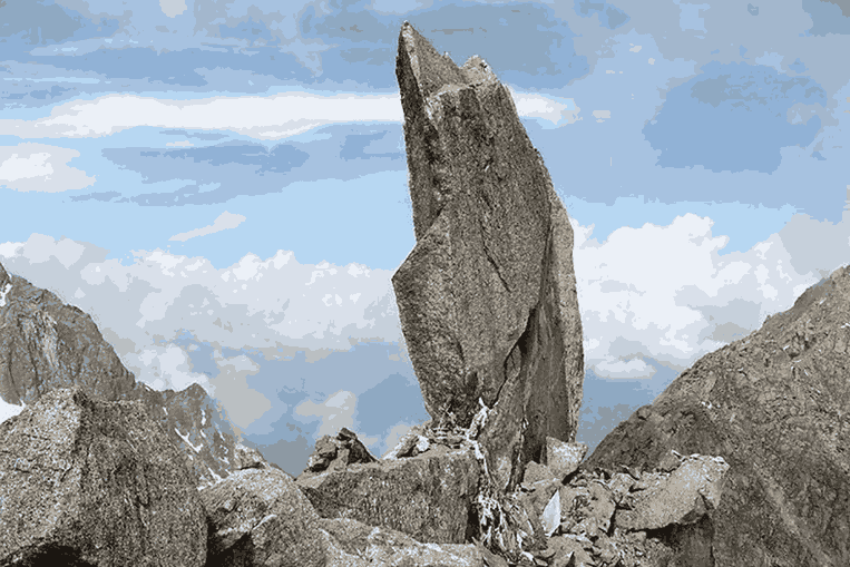
The Kinner Kailash trek is not merely a high-altitude adventure — it is a parikrama, a sacred circumambulation around one of the holiest peaks in the Hindu tradition. The spiritual centrepiece is a natural 79-foot rock pillar, widely believed to be a living manifestation of Lord Shiva.
Local legend and thousands of eyewitness accounts describe this Shivling changing colour throughout the day — appearing white at dawn, golden yellow by midday, saffron in the afternoon, and deep blue-black at dusk. Whether you interpret this as light physics or divine miracle, the sight leaves no one unmoved.
For spiritual travellers, the Kinner Kailash trek holds the same sacred weight as a journey to Kedarnath, Badrinath, or the Amarnath Cave. Many pilgrims undertake this trek barefoot as an act of devotion. Plan your visit with reverence, preparation, and the humility this mountain demands.
Permits and Registration: Everything You Need Before You Go
All visitors to Kinnaur district — whether trekkers or pilgrims — must hold a valid Inner Line Permit (ILP). This is a border area requirement due to Kinnaur's proximity to Tibet. In addition, a specific Kinner Kailash trek registration is issued by the local Forest or Tourism Department at Reckong Peo.
| Permit Type | Issued By | Required For |
|---|---|---|
| ILP | SDM, Reckong Peo | All visitors |
| Trek Registration | Forest/Tourism | Trail entry |
| Medical Certificate | Doctor (MBBS) | All trekkers |
For Foreign Nationals: International trekkers may face additional restrictions due to the area's proximity to the Indo-Tibetan border. Always verify current rules with the District Administration Kinnaur or a registered Himachal Pradesh trekking operator well in advance of your trip.
How Difficult is the Kinner Kailash Trek?
The Kinner Kailash trek is officially graded Difficult to Very Difficult. Here is why this rating is well-earned:
- Steep, rocky, and often loose trail with very few switchbacks
- Rapid elevation gain of nearly 2,000 metres in just 14 km
- Exposed ridgelines with serious fall risk in wet or icy conditions
- High altitude fatigue and AMS risk above 3,500 m
- Very limited rescue infrastructure beyond Lalanti campsite
- No permanent tea shops or resupply points above Thangi
That said, thousands of pilgrims — including elderly devotees and children — complete this trek every season. Success depends on three things: physical preparation, proper acclimatisation, and a certified local guide. Do not attempt this trek solo.
Tip: Spend at least one full night in Reckong Peo (2,290 m) before beginning the trek. This gives your body a first acclimatisation step that significantly reduces AMS risk on Day 3 at 15,000+ feet.\
Packing List and Essential Gear for Kinner Kailash
At Kinner Kailash height in feet (nearly 20,000 ft at the summit, and ~15,000 ft at the trekking high point), the right gear is not optional. Pack light, but pack right.
Clothing and Protection
- Thermal base layers — top and bottom
- Fleece or down mid-layer
- Waterproof, windproof outer shell jacket
- Quick-dry trekking trousers
- Warm gloves, balaclava, and wool hat
- Gaiters for loose and rocky sections
- High-ankle, waterproof trekking boots (well broken in)
Gear and Safety Equipment
- Trekking poles — essential on the steep descent
- Headlamp with extra batteries
- Sleeping bag rated to −10°C
- First aid kit including Diamox (for altitude sickness)
- Water purification tablets or a filter straw
- High-SPF sunscreen (SPF 50+) and UV-blocking sunglasses
- Emergency whistle and lightweight space blanket
- Pulse oximeter to monitor blood oxygen levels
Final Thoughts: Is the Kinner Kailash Trek Worth It?
For every kilometre of the Kinner Kailash trek distance — all 14 of them, gained steeply upward through one of the most dramatic landscapes on earth — there is a reward that no photograph can capture.
Standing before the 79-foot Shivling as the first light turns it gold. The silence of the high Himalayan air. The knowledge that millions of believers have walked this exact path across the centuries. This is what makes the Kinner Kailash trek extraordinary.