You have heard of Char Dham. But have you heard of the Himalayan pilgrimage that makes even seasoned trekkers drop to their knees — literally?
Shrikhand Mahadev is not just a trek. It is a test of faith, fitness, and the fierce will to stand before one of Lord Shiva's most remote abodes in the Himalayas. At 5,227 metres above sea level, this sacred peak in Himachal Pradesh draws thousands of pilgrims and adventure seekers every year — but only during a narrow window of a few months.
This guide covers everything — the best time, Shrikhand Mahadev trekking distance, route map, 2025 opening date, cost breakdown, and expert preparation tips.
What Is the Shrikhand Mahadev Trek?
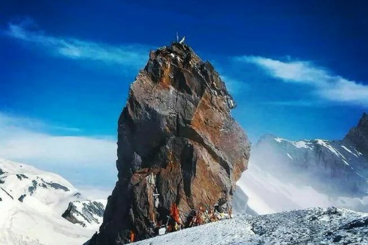
Shrikhand Mahadev is a naturally formed Shivling (a stone pinnacle resembling Lord Shiva's symbol) located in the Kullu district of Himachal Pradesh, near the Great Himalayan National Park. It is considered one of the holiest pilgrimage sites in all of Hinduism.
The trek starts from Jaon Village, located about 150 km from Shimla via Rampur Bushahr. Unlike commercialised treks, the Shrikhand trek is deeply spiritual in nature, attracting barefoot pilgrims alongside experienced mountaineers.
Shrikhand Mahadev Height in Feet and Metres
| Detail | Specification |
|---|---|
| Peak Name | Shrikhand Mahadev |
| Height | 5227 m (17149 ft) |
| Starting Point | Jaon Village |
| Nearest Town | Rampur Bushahr |
| State | Himachal Pradesh, India |
| Deity | Lord Shiva |
Best Time to Trek Shrikhand Mahadev: Month-by-Month Breakdown
The best time to trek Shrikhand Mahadev is between July and mid-September. This is when the trail is open, the snow is manageable, and the weather is at its safest for high-altitude trekking. Outside this window, the route remains buried under heavy snow and is officially closed.
June (Late June — Early Season)
- Trail opens: Last week of June (subject to snowmelt)
- Temperatures: 5°C to 15°C at higher altitudes
- Crowd level: Low
- Recommended for: Experienced trekkers only
July — The Peak Pilgrimage Month
July is widely regarded as the best month for the Shrikhand Kailash trek. The monsoon brings some rainfall to lower elevations, but the higher alpine zones remain relatively dry. Most pilgrims begin their journey in July, particularly around the Shrikhand Yatra (annual pilgrimage).
- Trail condition: Good to excellent above the treeline
- Temperatures: 8°C to 18°C
- Crowd level: High (pilgrimage season in full swing)
- Best for: Pilgrims and first-time high-altitude trekkers
August — Beautiful but Watch the Weather
August offers stunning views as the alpine meadows (bugyals) are in full bloom. However, the monsoon can cause slippery trails in lower sections. Always check the weather forecast before starting.
- Trail condition: Good, occasional muddy patches
- Temperatures: 7°C to 16°C
- Crowd level: Moderate
- Best for: Nature lovers and spiritual trekkers
Mid-September — Last Window Before Closure
The trail typically closes by mid-to-late September as snow begins to accumulate. This period offers cleaner trails, fewer crowds, and crystal-clear views. However, plan your trip early in the month to avoid being caught by an early snowfall.
- Trail condition: Excellent (drier, clearer skies)
- Temperatures: 2°C to 12°C
- Crowd level: Low
- Best for: Photographers, experienced trekkers
Season Not Recommended: October to May
The trail is officially closed from October to June. Heavy snowfall makes the route impassable and extremely dangerous. No official support or rescue operations are available during this period.
Shrikhand Mahadev Trek Opening Date 2026
The Shrikhand Mahadev trek opening date 2026 has not been officially announced as of the time of writing. Historically, the Himachal Pradesh government and the local administration in Kullu announce the opening date based on snowmelt conditions, trail safety surveys, and auspicious calendar dates.
- Expected opening: Late June 2026 (approximately June 25 to July 5)
- Peak yatra period: July 10 to August 20, 2026
- Expected closing: Mid-September 2026
- Official source: Kullu District Administration, Himachal Pradesh
- Always verify the latest date before planning — snowfall can delay the opening by days or weeks
Shrikhand Mahadev Trekking Distance and Route Map
Understanding the ShrikhandMahadev trekking distance is essential to preparing correctly. This is not a casual day hike. The total Shrikhand Mahadev trek distance is approximately 32 to 35 kilometres one way, making it 64 to 70 km for a complete round trip.
| Day | Route | Distance |
|---|---|---|
| 1 | Jaon → Thachda | ~9 km |
| 2 | Thachda → Bheema Dwar | ~10 km |
| 3 | Bheema Dwar → Summit | ~7 km |
| 4 | Summit → Bheema Dwar / Thachda | ~14 km |
| 5 | Thachda → Jaon | ~9 km |
The Shrikhand Mahadev trek km count increases significantly with altitude gain. The final push to the summit involves crossing steep snowfields and rocky terrain — often the most physically demanding section.
Key Points on the Shrikhand Mahadev Trek Map
- Jaon Village (Base Camp) — 2,400 m
- Thachda Camp — 3,200 m
- Kali Ghati — 4,200 m (most difficult section, known for landslide risk)
- Bheema Dwar — 4,500 m (last campsite before summit)
- Shrikhand Mahadev Peak — 5,227 m
A detailed Shrikhand Mahadev trek map is available from the Kullu District Administration and is usually provided by registered local guides. Always carry a physical copy as mobile signals are absent beyond Thachda.
How to Prepare for the Shrikhand Mahadev Trek
Physical Fitness Requirements
- Begin cardiovascular training (running, stair climbing) at least 6 to 8 weeks before departure
- Strength training for legs, core, and back
- Practice day hikes with a loaded backpack (8–12 kg)
- Prior high-altitude trek experience (3,500 m+) strongly advised
Essential Gear Checklist
- Warm layering system: base layer, fleece, windproof outer jacket
- Waterproof trekking boots (ankle support essential)
- Trekking poles — mandatory for Kali Ghati section
- Sleeping bag rated to -10°
- Headlamp with extra batteries
- High-altitude sunscreen (SPF 50+) and UV-protective sunglasses
- Water purification tablets and a 2-litre water bottle
- Personal first aid kit including altitude sickness medication (Diamox — consult a doctor)
- Rain poncho or waterproof pack cover
- Dry food: nuts, energy bars, glucose
Altitude Acclimatisation Tips
- Spend at least one night in Jaon Village before starting the trek
- Ascend slowly — do not exceed 500 m altitude gain per day above 3,000 m
- Stay hydrated: drink 3–4 litres of water daily
- Never ignore symptoms of Acute Mountain Sickness (AMS): headache, nausea, dizziness
Permits, Regulations & Safety Guidelines
- The Shrikhand Mahadev trek requires registration with the local administration in Jaon Village or at a registration camp set up by the Kullu district authorities during the yatra season. Key rules:
- Carry a valid government-issued photo ID at all times
- Groups should not separate — always trek with a partner or guide
- No alcohol or non-vegetarian food is permitted on the trek (religious sanctity rules)
- Leave No Trace: all waste must be carried back to the base
- Solo trekking is officially discouraged due to terrain difficulty
- Emergency rescue services are available at Bheema Dwar during the official season